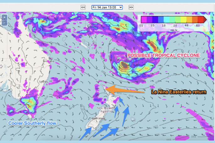
A tropical low near Fiji is expected to reach storm status, with gale force winds around the centre, which means it will become a named tropical cyclone, says a WeatherWatch spokesperson on Sunday morning.
'For now this is a marginal storm, with the Fiji Met Service only expecting Category 1 strength initially.
'Computer modelling this past week has been quite messy, with some days showing a storm forming and other days showing a very large low instead.”
Large lows can stretch the energy further which reduces the winds overall, making it harder to reach that "tropical cyclone" status.
'The tracking is also a bit sluggish, expected to be zig zagging about for a while at sea between Fiji and Vanuatu,” says a WeatherWatch spokesperson.
'As for New Zealand - long range data suggests it may get close, but it's not locked in yet if NZ will be impacted. Either way though, the storm may increase rips, currents and wave heights at some northern beaches at the end of this coming week even if it remains well offshore.”
Powerful high pressure over the South Island is expected to 'push back' against the storm as it tracks south.
Severe marine heatwave on east coast of the North Island
WeatherWatch reports that marine heatwave conditions are likely to persist for the east coast of the North Island from January 6 - 12 and in the Wairarapa region, which is still experiencing a severe marine heatwave.
Water temperatures around Raglan and Taranaki will continue to increase but conditions need to persist for longer to be classified as marine heatwaves.
The Cook Strait and Chatham Islands are no longer experiencing marine heatwave as water temperatures decrease, but are likely to rise again at the end of next week.
For the South Island, although the waters will be warmer than the long-term average, no marine heatwaves are expected over the coming week.
New Zealand continues to lean drier than average
Hot weather is likely to expand further across New Zealand today with most places recording temperatures in the mid to late 20s and some in the early 30s. This hot dry weather is likely to speed up the chances of water restrictions in some areas.
'We don't expect to lock in the potential cyclone's chances of rain in NZ for a number of days - but your local WeatherWatch.co.nz or RuralWeather.co.nz forecasts are already crunching the data and giving you the chance of rainfall in seven to ten days' time in percentage form,” says a WeatherWatch spokesperson.
'At this stage our IBM data shows an increased chance of windier easterlies and cloud - but the rain still being held at sea. Our public forecast data is updated every hour of every day and within IBM it's as frequent as every 15 minutes - so it's the current best thinking on the planet).
A fine line between very dry and very wet later this coming week as a likely tropical low gets very close to New Zealand.

0 comments
Leave a Comment
You must be logged in to make a comment.