Large swells are being predicted for the Bay of Plenty as Cyclone Cody tracks towards New Zealand.
Cody intensified overnight to a Category 2 storm on Wednesday, but is now a category 1 storm today, says WeatherWatch.co.nz
WeatherWatch.co.nz says La Nina is helping boost sea surface temperatures in our part of the world and the marine heatwave occurring in parts of the North Island may help keep Cody a powerful storm as it tracks past later this weekend or early next week.
#CycloneCody is now Category 1. Today the storm transitions from Fiji authorities to @MetService.
— WeatherWatch.co.nz (@WeatherWatchNZ) January 12, 2022
The storm will technically lose the "tropical cyclone" status before it reaches NZ - but note damaging gales & heavy rain WILL remain. More details later this morning on NZ impact. pic.twitter.com/0ljuPN9T1E
'The storm will technically lose the "tropical" portion of its name in the coming day or two, but damaging gales & rain may still be significant as it moves towards,” says the weather organisation.
MetService's forecast for 1am Friday has the cyclone lying southwest of Fiji.
It is expected to move is expected to move south or southeast over the next couple of days, says an update on the MetService website.
'Some further intensification is possible in the near term, then tomorrow the system should begin to lose its tropical characteristics as it encounters cooler seas and strong winds aloft.”
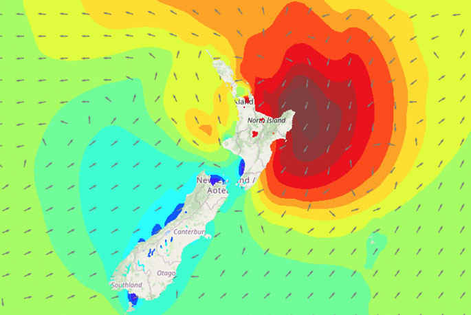
Tropical Cyclone Cody is approaching this weekend, the first signs are making it onto our Severe Weather Outlook, including a high risk of heavy rain in Gisborne. This map, and all our other forecasts will be upgraded frequently in the coming days as we learn more about TC Cody. pic.twitter.com/oyoHg9Bvf3
— MetService (@MetService) January 12, 2022
Outlook to 1am Mon, 17 Jan (NZT)
Tropical cyclone Cody is likely to be reclassified later this week, and most outlooks suggest it will move south and approach the North Island later on Sunday as a deep low.
No other significant lows of interest are expected, says the MetService.
Further updates are expected later this morning.

0 comments
Leave a Comment
You must be logged in to make a comment.