Parts of NZ are in a heatwave right now with highs today again above average. With things drying out rapidly the forecast of rain this weekend will be welcome by many.
WeatherWatch.co.nz has been receiving updates from farmers saying just how little rain has fallen this year so far.
Out on the Waikato plains farmer Craig Clausen told WeatherWatch.co.nz this week he's concerned about how dry things are for this time of year. "64mm rain for October and 701mm year to date. Last driest year was in 2013 with 950mm. That year we were 749 by the end of October".
Average Waikato rainfalls are usually around 1100mm so a total of 701mm so far in 2019 with just 7 weeks of the year left is a very significant number and for many farmers will be concerning heading into the dry, hot, months unless rain arrives soon.
WeatherWatch.co.nz says last week that a 'big dry' had already formed this year in some regions of NZ which was concerning before summer had even started. In that same story we mentioned how warm November rains could make a big positive difference. Here's the good news - rain may well fall this weekend and be heavy for some dry North Island farms, gardens and orchards.
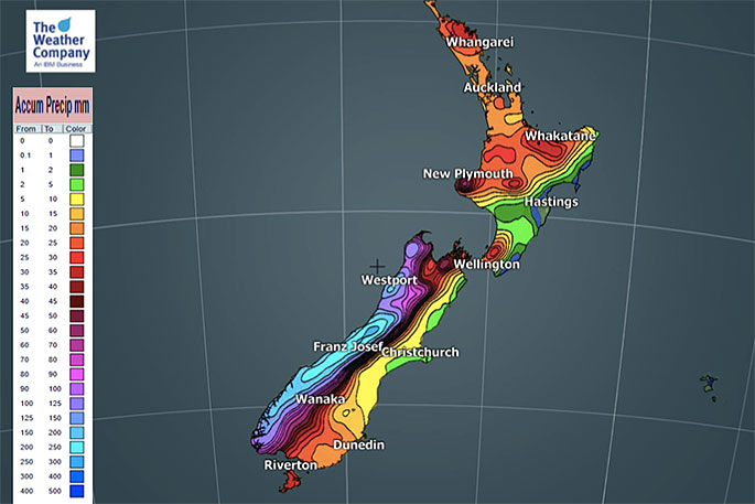
Due to sub-tropical connections the rain may be heavy at times. However the nature of the set up - along with our mountains and ranges - means some areas will miss out on soaking rains. As you can see in Map 2 (7 day outlook at the bottom) the heavy rain areas are fairly focused.
The West Coast has heavy rain from this Thursday which is why their totals are greatest.


0 comments
Leave a Comment
You must be logged in to make a comment.